
Datei:PIA21260 - Earth and Its Moon, as Seen From Mars.jpg
Es ist keine höhere Auflösung vorhanden.
PIA21260_-_Earth_and_Its_Moon,_as_Seen_From_Mars.jpg (657 × 358 Pixel, Dateigröße: 7 KB, MIME-Typ: image/jpeg)
| Diese Datei und die Informationen unter dem roten Trennstrich werden aus dem zentralen Medienarchiv Commons eingebunden. Weitere Informationen und eine Kontaktmöglichkeit zum Urheber sind dort zu finden. |
Zur Beschreibungsseite auf Commons |
Beschreibung
| Beschreibung |
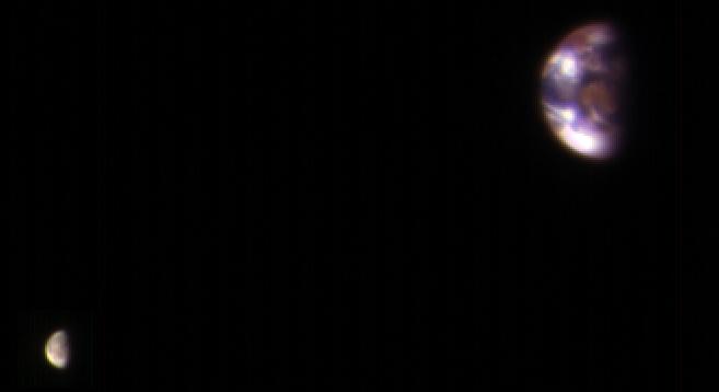
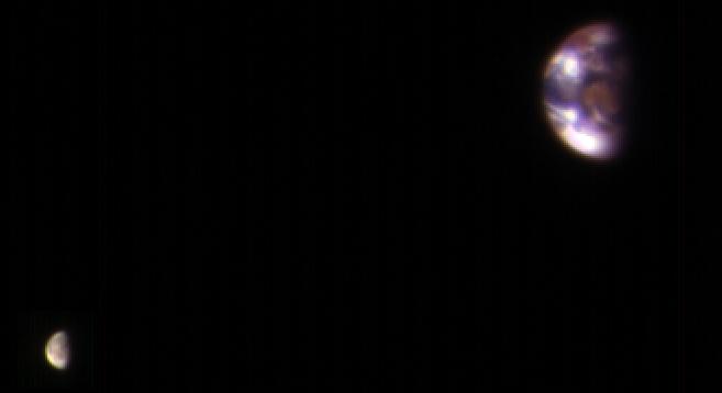
English: This composite image of Earth and its moon, as seen from Mars, combines the best Earth image with the best moon image from four sets of images acquired on Nov. 20, 2016, by the High Resolution Imaging Science Experiment (HiRISE) camera on NASA's Mars Reconnaissance Orbiter. Each was separately processed prior to combining them so that the moon is bright enough to see. The moon is much darker than Earth and would barely be visible at the same brightness scale as Earth. The combined view retains the correct sizes and positions of the two bodies relative to each other. HiRISE takes images in three wavelength bands: infrared, red, and blue-green. These are displayed here as red, green, and blue, respectively. This is similar to Landsat images in which vegetation appears red. The reddish feature in the middle of the Earth image is Australia. Southeast Asia appears as the reddish area (due to vegetation) near the top; Antarctica is the bright blob at bottom-left. Other bright areas are clouds. These images were acquired for calibration of HiRISE data, since the spectral reflectance of the Moon's near side is very well known. When the component images were taken, Mars was about 127 million miles (205 million kilometers) from Earth. A previous HiRISE image of Earth and the moon is online at PIA10244. The University of Arizona, Tucson, operates HiRISE, which was built by Ball Aerospace & Technologies Corp., Boulder, Colo. NASA's Jet Propulsion Laboratory, a division of Caltech in Pasadena, California, manages the Mars Reconnaissance Orbiter Project for NASA's Science Mission Directorate, Washington. |
| Datum | (published 2017-01-06) |
| Quelle | Catalog page · Full-res (JPEG · TIFF) |
| Urheber | NASA/JPL-Caltech/Univ. of Arizona |
Diese Mediendatei wurde vom Jet Propulsion Lab der US-amerikanischen National Aeronautics and Space Administration (NASA) unter der Datei-ID PIA21260 kategorisiert. Diese Markierung zeigt nicht den Urheberrechtsstatus des zugehörigen Werks an. Es ist in jedem Falle zusätzlich eine normale Lizenzvorlage erforderlich. Siehe Commons:Lizenzen für weitere Informationen. Sprachen:
|
 |
This media is a product of the Mars Reconnaissance Orbiter mission Credit and attribution belongs to the mission team, if not already specified in the "author" row |
Simulated comparison:

Lizenz
| Diese Datei ist gemeinfrei (public domain), da sie von der NASA erstellt worden ist. Die NASA-Urheberrechtsrichtlinie besagt, dass „NASA-Material nicht durch Urheberrecht geschützt ist, wenn es nicht anders angegeben ist“. (NASA-Urheberrechtsrichtlinie-Seite oder JPL Image Use Policy). | ||
 |
Warnung:
|
Dateiversionen
Klicke auf einen Zeitpunkt, um diese Version zu laden.
| Version vom | Vorschaubild | Maße | Benutzer | Kommentar | |
|---|---|---|---|---|---|
| aktuell | 22:29, 6. Jan. 2017 | | 657 × 358 (7 KB) | PhilipTerryGraham | User created page with UploadWizard |
Dateiverwendung
Die folgenden 2 Seiten verwenden diese Datei:
Globale Dateiverwendung
Die nachfolgenden anderen Wikis verwenden diese Datei:
- Verwendung auf ar.wikipedia.org
- Verwendung auf ca.wikipedia.org
- Verwendung auf en.wikipedia.org
- Verwendung auf es.wikipedia.org
- Verwendung auf eu.wikipedia.org
- Verwendung auf fa.wikipedia.org
- Verwendung auf he.wikipedia.org
- Verwendung auf hr.wikipedia.org
- Verwendung auf ja.wikipedia.org
- Verwendung auf mnw.wikipedia.org
- Verwendung auf ro.wikipedia.org
- Verwendung auf ru.wikipedia.org
- Verwendung auf simple.wikipedia.org
- Verwendung auf th.wikipedia.org